- About us
- Research fields
- DIGITAL – Institut für Digitale Technologien
- MATERIALS – Institut für Sensorik, Photonik und Fertigungstechnologien
- ROBOTICS – Institut für Robotik und Flexible Produktion
- COREMED – Zentrum für Regenerative Medizin und Präzisionsmedizin
- HEALTH – Institut für Biomedizinische Forschung und Technologien
- LIFE – Institut für Klima, Energiesysteme und Gesellschaft
- POLICIES – Institut für Wirtschafts-, Sozial und Innovationsforschung
- Business areas
- Products & services
- Research infrastructure
- Beteiligungen
- Career
- Aktuelles
- Publications
- Kontakt zu uns


ESERCOM-D: Sichere und effiziente Straßen
RUNNING TIME:
10/2024
—
09/2027
Total project duration:
3 Years
Fotomontage ESERCOM-D, Foto: JOANNEUM RESEARCH/ESA
The project
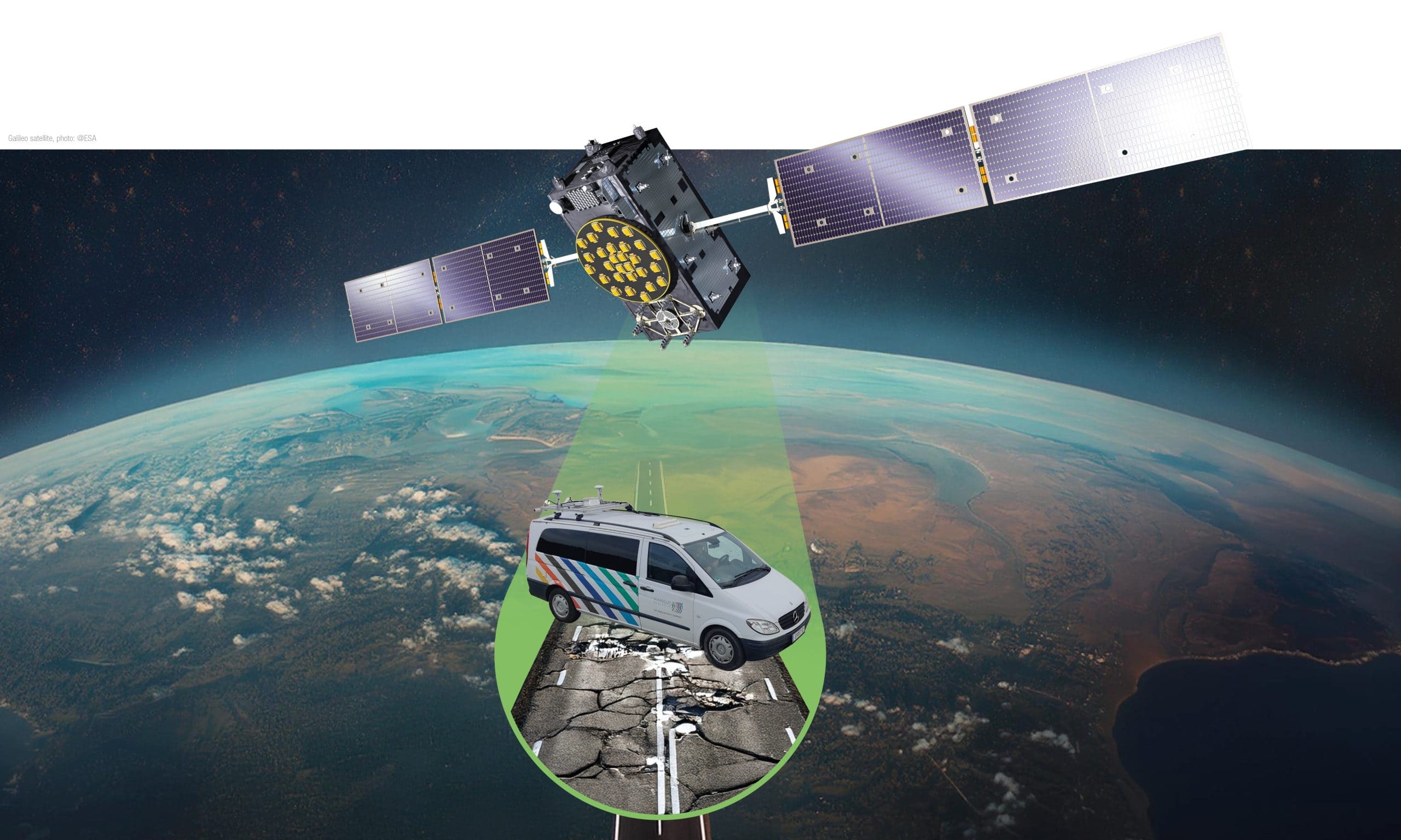
The project addresses the issue of road wear by detecting and mapping it at an early stage. The goal is to reduce the costs of road maintenance and extend the lifespan of road surfaces. The project team aims to create a demonstrable service that promotes greener and smarter road use, optimizes road maintenance, and increases road safety. The objective is to automate the entire process from road condition monitoring to decision-making, while also establishing relationships with standardization bodies and expanding the use of EGNSS in the road and automotive industries.
Our activities in the project
In the ERSERCOM-D project, JOANNEUM RESEARCH is managing the overall solution and is leading the technical development for recording, mapping and analysing road conditions. To this end, it is developing a low-cost sensor platform and carrying out extensive data collection on motorways and rural roads. The collected data will be processed and transferred to a digital twin to accurately detect road damage. High-precision localisation plays a key role, both in data collection by the measurement vehicle and in localising road damage and communicating decisions to autonomous vehicles.

Research groups
Downloads
Customers
This project has received funding from the European Union Agency for the Space Programme under the European Union’s Horizon Europe Framework Programme, grant agreement No 101180176.
Project partners
Virtual Vehicle Research GmbH,
ASFINAG
NLS - National Land Survey of Finnland
FH -Oberösterreich & LOGISTIKUM
Evolit Consulting GmbH
Enide
Motere
Politecnico di Milano
Project details
Road wear stands as a pervasive challenge and a significant financial burden in infrastructure upkeep. Detecting and mapping road wear early and in detail can alleviate these costs and simultaneously extend the lifespan of road surfaces. The project team successfully finalised the EGNSS-project ESRIUM (TRL 6) in November 2023, identified necessary technological and standardisation steps for entering into the market and targets this tender as an optimal window-of-opportunity for doing so. The overall objective of ESERCOM-D is to facilitate standardization efforts through the implementation of a demonstrable service (TRL 8), which fosters greener and smarter road usage, optimizes road maintenance, and increases road safety. In doing so, the automation of the complete chain from road condition monitoring to smart decision making will be demonstrated.
Moreover, the project seeks to establish, contact and create liaison with key standardization bodies and expand the utilization of EGNSS in the road and automotive industry. The goals emphasize the importance of aligning developments with international industry-accepted certification and standardization schemes.
Through comprehensive testing and validation in real-life environments, ESERCOM-D aims to provide proof of concept demonstrators for standardization concepts, ensuring the sustainable impact and widespread acceptance of its outcomes. The project's commitment to transparency, user acceptance assessment, and fostering sustainable impact underscores its excellence in addressing current challenges and pushing the boundaries of the state of the art in road wear assessment and maintenance.
Objectives of the project:
- Identification of standardization gaps, linkage to the relevant data value chain and derivation of standardization concepts
- Construction of the road wear sensor system at TRL 7
- Digital twin case study at one road operator
- Development of EGNSS-based localization systems providing accurate, reliable and authenticated position
- Assessment of impact and user acceptance
The implementation is based on three specific use cases:
- UseCase 1: Wear-map content provision
During the predecessor project ESRIUM a prototype of a road sensing and damage mapping system was developed. The system detects road damages with a sensor-equipped vehicle with an accuracy in the range of some centimetre. The collected data is mapped to the road network. The result is a road wear map. The road damages in the map include information about the type of road damage, the severity, and the time of detection. The system provides a software based interface to external systems to retrieve the information.
- Use Case 2: GNSS-corrections provision
The road operator provides delivers EGNSS-correction data to end users for enhancing the positioning accuracy of end users’ vehicles on different types of roads (highways and secondary road network) from meters to some centimetres. The data elements are provided via different communication channels, either C-ITS or directly via the EGNSS satellite or Internet. The position data is secured using Galileo’s OSNMA to support applications with high demands on the level of trust.
- Use Case 3: Infrastructure information & support
A traffic management system uses road wear data and incident related data (e.g., broken vehicle on the road) from the legacy traffic infrastructure to provide lane-specific warnings and recommendations to vehicle drivers via C-ITS. The information is generated automatically and and in near real-time based on the different data sources. The output of the data processing are safety-related messages or recommendations on changing the lane or the in-lane lateral offset. Drivers adapt their behaviour on the basis of the information provided.
Funding organisation
Projektbeteiligte
Related projects
SHAPING THE FUTURE, TOGETHER
JOANNEUM RESEARCH provides innovation and technology services in the field of applied research. As a research company working on behalf of various federal provinces and regions in Austria, our expertise shapes the development of our modern society and economy – sustainably, and always with a focus on people. As a multidisciplinary team working in a flexible set-up that fosters innovation, we always live up to the highest social and scientific standards.