• Menu menu
  • menu Menü öffnen
Projects -  
Digital

DeepDigitalForest

Total project duration:

3 Years

Deepening and optimisation of multi-phase inventory & survey methods for the digitalisation of the forest

The project

The aim of the project was to develop a cost-efficient workflow for the digitisation of the forest, ranging from the acquisition of airborne remote sensing data of medium to very high point density and its processing, to optimised field surveys using terrestrial laser scanning, to a tablet application to support forest management.

Our activities in the project

JR's task in the project was to develop deep learning (DL) methods for recognising individual trees from LiDAR data with a high point density.

Keine Datei zugewiesen.

Österreichische Forschungsförderungsgesellschaft FFG

UMWELTDATA Gesellschaft m.b.H. (Koordination)

AeroMap GmbH

E.C.O. Institut für Ökologie Jungmeier GmbH

Souveräner Malteser-Ritter-Orden Waldbetrieb Ligist

Project details

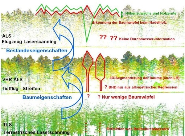
In the DeepDigitalForest project, the concept of a consistent, cross-company and cost-efficient workflow for digitising the forest is being expanded by the acquisition and evaluation of flight strips with very high-resolution data (VHR-ALS, low-altitude flight strips). These enable a more precise description of individual trees and must be integrated into the existing system of aeroplane ALS and terrestrial surveys. In addition, a method patented by Umweltdata GmbH for terrestrial laser scanning in the forest is to be integrated into the workflow.

Another focus is on advanced AI-based extraction of tree properties, on expanding the tablet app for complex issues and very large planning areas and on obtaining indicators for monitoring structural richness and biodiversity in forests. Overall, the cost-efficient application of the methods in very large regions or entire nations is to be promoted and established as an international standard.

Projektbeteiligte

Related projects

Skip to content