
Satellite-based monitoring system for cocoa cultivation in West Africa
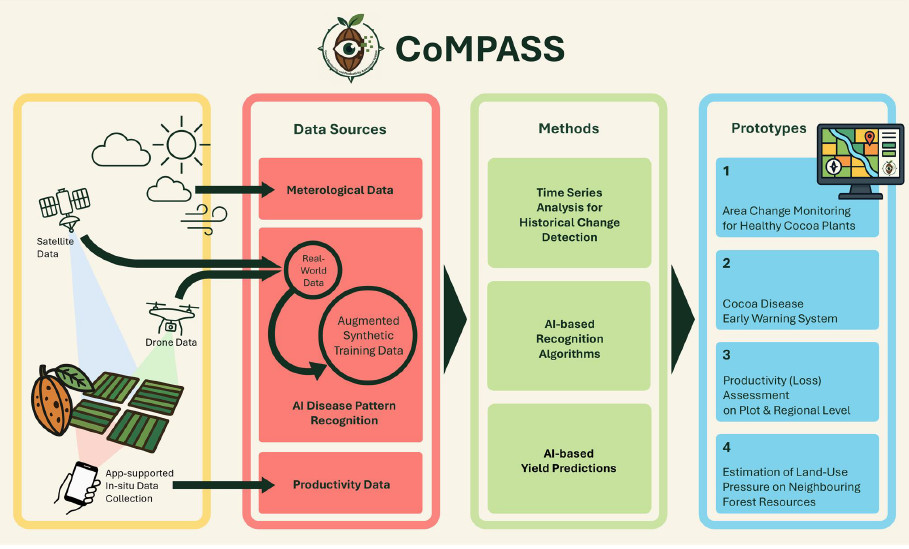
As part of the FFG project CoMPASS (Cocoa Monitoring and Productivity Assessment System), the DIGITAL Institute at JOANNEUM RESEARCH has been developing a satellite-based monitoring system for cocoa cultivation in West Africa since October. The aim is to map cocoa plantations, assess their vitality and detect damage caused by diseases such as Cocoa Swollen Shoot Virus Disease (CSSVD) at an early stage. With the help of satellite data, drone images, weather and climate data, and synthetically generated training data, the aim is to forecast crop failures and assess the spread of pathogens. The project is coordinated by the Viennese start-up Beetle ForTech, with JOANNEUM RESEARCH and the Graz-based technology company Another Earth EOD FlexCo as project partners.
The project team creates maps and spatial statistics on plantation distribution, vitality, harvest forecasts and forest conditions. These data not only serve to improve local agriculture, but also support the implementation of the EU Deforestation Regulation (EUDR), which will link cocoa imports to environmental criteria in the future.
CoMPASS thus also contributes to the implementation of the EU Deforestation Regulation by identifying areas where illegal clearing has taken place or where there is high pressure on land use.
Satellites, time series and climate data in combination
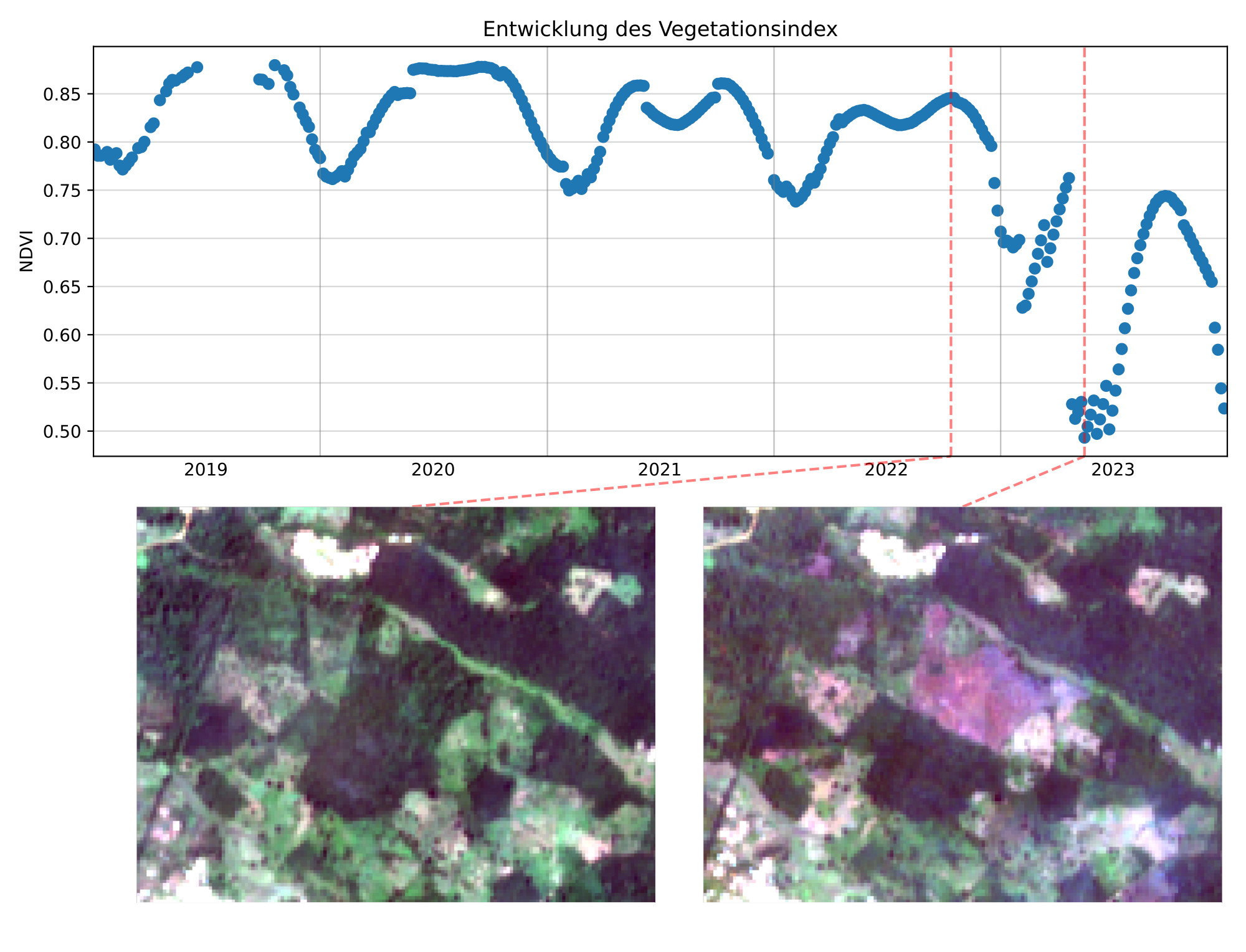
The core of the technical implementation is the analysis of time series from Sentinel-2 satellite images, which reveal changes in plant vitality over several years. Sentinel-2 is an environmental satellite mission of the European Space Agency (ESA) as part of the Copernicus programme. This satellite data is combined with weather and climate data to derive trends and make forecasts. Comparable methods have already been used successfully in bark beetle monitoring – now they are being transferred to tropical regions.
Our project partner Beetle ForTech uses drones to take high-resolution images of individual cocoa plantations in Côte d'Ivoire in order to accurately assess the condition of the plants directly on site. We then use this data to develop AI-based classification models for satellite images. Additional in-situ data, which is also collected by cocoa farmers via a dedicated crowdsourcing app, provides important information on the vitality of the crops, the temporal and spatial occurrence of diseases and disease patterns, and local harvest yields," adds geoscientist Deutscher. The aim is to use drone imagery to detect even small-scale damage that is difficult to see in satellite images and to use this to obtain reliable reference data for the development and validation of AI-supported analysis models.
‘In tropical regions with heavy rainy and dry seasons in particular, the continuous observation of vegetation using optical satellite data is a particular challenge due to changing cloud cover. We therefore analyse cocoa cultivation areas continuously and retrospectively over longer periods of several years in order to identify current changes in vitality at an early stage,’ explains Deutscher.
In addition, the project team is investigating the inclusion of data from the new ESA BIOMASS satellite, which provides information on forest height and above-ground biomass. This can be used to check whether and where natural barriers such as adjacent forests can reduce the spread of pathogens in cocoa plants. CSSV, for example, is transmitted by mealybugs, which have limited mobility.
According to scientific studies, agroforestry plantations, in which cocoa trees grow alongside shade-providing trees, could also curb the spread of CSSVD, as the diverse vegetation structure creates natural barriers and makes the microclimate less favourable for the pests.
Artificial data for real challenges
AI models are usually trained using large amounts of data. Since, for logistical reasons, only a small amount of reference data can be collected on site in the project, additional synthetic satellite images are used. This synthetic data expands the training basis for AI models, which are then designed to automatically detect disease patterns, yield losses and changes in vitality. This synthetic data is generated by Another Earth, an Austrian company specialising in synthetic Earth observation data.
The aim of the CoMPASS project is to develop a prototype for digital cocoa monitoring that can serve as an economic and sustainable basis for decision-making for cocoa producers, cooperatives, traders, chocolate manufacturers, agricultural support programmes and certification bodies along the supply chain. The findings from the project should also be transferable to other agricultural crops in the long term.
It is important that we do not run out of chocolate in the future.
The project is funded as part of the ASAP programme of the Austrian Research Promotion Agency (FFG).