- About us
- Research fields
- DIGITAL – Institut für Digitale Technologien
- MATERIALS – Institut für Sensorik, Photonik und Fertigungstechnologien
- ROBOTICS – Institut für Robotik und Flexible Produktion
- COREMED – Zentrum für Regenerative Medizin und Präzisionsmedizin
- HEALTH – Institut für Biomedizinische Forschung und Technologien
- LIFE – Institut für Klima, Energiesysteme und Gesellschaft
- POLICIES – Institut für Wirtschafts-, Sozial und Innovationsforschung
- Business areas
- Products & services
- Research infrastructure
- Beteiligungen
- Career
- Aktuelles
- Publications
- Kontakt zu uns


FloraMon: Monitoring of plants
RUNNING TIME:
01/2020
—
05/2023
Total project duration:
3 Years
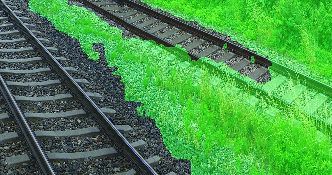
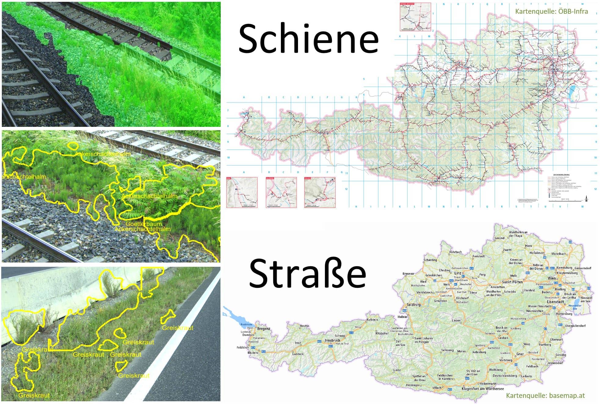
Bewuchsdetektion entlang einr Bahnstrecke, Bild JOANNEUM RESEARCH
The project
Automated plant monitoring on Austria's railways and roads enables efficient and environmentally friendly vegetation control and ensures safety.
Our activities in the project
The camera prototype system developed by us is used for the comprehensive recording of vegetation density as well as relevant and problematic plant species. This includes the visual recording of plants along the rail and road network at very high speed, the evaluation of the location and frequency of the occurrence of specific plant species (e.g. neophytes) using AI methods, and the clear presentation of this information in geographic information systems (GIS).

Research groups
Downloads
Customers
Project partners
Project details
Flora monitoring for ÖBB and ASFINAG
Plants can damage structures on traffic routes and endanger safety. The removal of the plants or the avoidance of vegetation means a high financial outlay for the operators of the transport infrastructure, e.g. the Austrian Federal Railways and the ASFiNAG, as well as a personal risk of accidents and damage for the users of this infrastructure.
In order to keep the impact on the environment to a minimum, plant protection products are only used where absolutely necessary. In order to achieve this, a selective and economical application of chemical and biological pesticides is necessary on the one hand, and on the other hand, the use of mechanical and thermal measures is necessary, depending on local conditions and existing vegetation. Some plant species can cause allergies, so knowing their locations is relevant for worker protection. In order to curb the spread of certain, very problematic plant species, early identification, the implementation of special measures and their success monitoring are necessary.
For all this, it is elementary to know which plant species grow, where, and to what extent. Only with this knowledge can plant-species-dependent and environmentally friendly vegetation control measures be planned and efficiently carried out by the infrastructure managers. This applies to transport infrastructure at the federal, state and local levels.
The prototype system developed in the FloraMon project is used to comprehensively record the vegetation density as well as relevant and particularly problematic plant species. This includes the imaging of plants along the rail and road network at very high speed, the evaluation of the location and frequency of the occurrence of specific plant species (neophytes and others) using AI methods, and the clear presentation of this plant information in geographic information systems (GIS).
FloraMon Recording Systems
- Modular image acquisition system for rail and road
- Ultra-high resolution (16k x 2k) for capturing small plants and fine plant parts
- Recording at high speed (100 km/h and more)
- Storage of image and geolocation in standardized format and at high frame rate
FloraMon Plattform Services
- Management of image data and its processing
- Service-Oriented Architecture
- For private and public cloud
- Integrates with existing clusters
FloraMon Plant Detection
- AI plant detection based on thousands of annotated training images
- Detection of vegetation regions along the rail network
- Detection of seven specific plant species along road and rail (field horsetail, ragweed, tree of gods, greiswort, silk plant, summer lilac, knotweed)
FloraMon GIS
- GIS Data Preparation for Users of Plant Information
- Density of vegetation and plant species along the rail network
- Overview and individual regions of a specific plant species along rail and road
- Open, standardised interface for data exchange with ÖBB and ASFINAG-GIS systems
Based on these FloraMon results, ÖBB and ASFiNAG will be able to efficiently plan and implement environmentally friendly vegetation control measures in the future, which will both reduce infrastructure maintenance costs and ensure the safety of road and rail users.
The Team
The FloraMon team unites the...
- User knowledge of ÖBB and ASFiNAG for the necessary vegetation control as well as the technical and operational framework conditions with the
- biohelp's biological knowledge of the occurrence and characteristics of the relevant plants and the
- JOANNEUM RESEARCH's technological research and development expertise in the field of high-speed image capture, AI-based crop detection and GIS processing in a cloud software.
The complementary knowledge enabled the development of the FloraMon system, which meets the requirements of the transport infrastructure operators ÖBB and ASFiNAG in the best possible way.
Support
FloraMon is funded by the Federal Ministry for Climate Action, Environment, Energy, Mobility, Innovation and Technology (BMK), ÖBB Infrastruktur AG and ASFINAG as part of the Mobility of the Future programme, Transport Infrastructure Research (vif). Details on the "Mobility of the Future" program can be found here.
Funding organisation
Projektbeteiligte
Related projects
SHAPING THE FUTURE, TOGETHER
JOANNEUM RESEARCH provides innovation and technology services in the field of applied research. As a research company working on behalf of various federal provinces and regions in Austria, our expertise shapes the development of our modern society and economy – sustainably, and always with a focus on people. As a multidisciplinary team working in a flexible set-up that fosters innovation, we always live up to the highest social and scientific standards.