- About us
- Research fields
- DIGITAL – Institut für Digitale Technologien
- MATERIALS – Institut für Sensorik, Photonik und Fertigungstechnologien
- ROBOTICS – Institut für Robotik und Flexible Produktion
- COREMED – Zentrum für Regenerative Medizin und Präzisionsmedizin
- HEALTH – Institut für Biomedizinische Forschung und Technologien
- LIFE – Institut für Klima, Energiesysteme und Gesellschaft
- POLICIES – Institut für Wirtschafts-, Sozial und Innovationsforschung
- Business areas
- Products & services
- Research infrastructure
- Beteiligungen
- Career
- Aktuelles
- Publications
- Kontakt zu uns


Mobility and Activity Model – Lakeside Park Klagenfurt
Duration:
07/2022
—
11/2022
Total Project Duration
5 Months
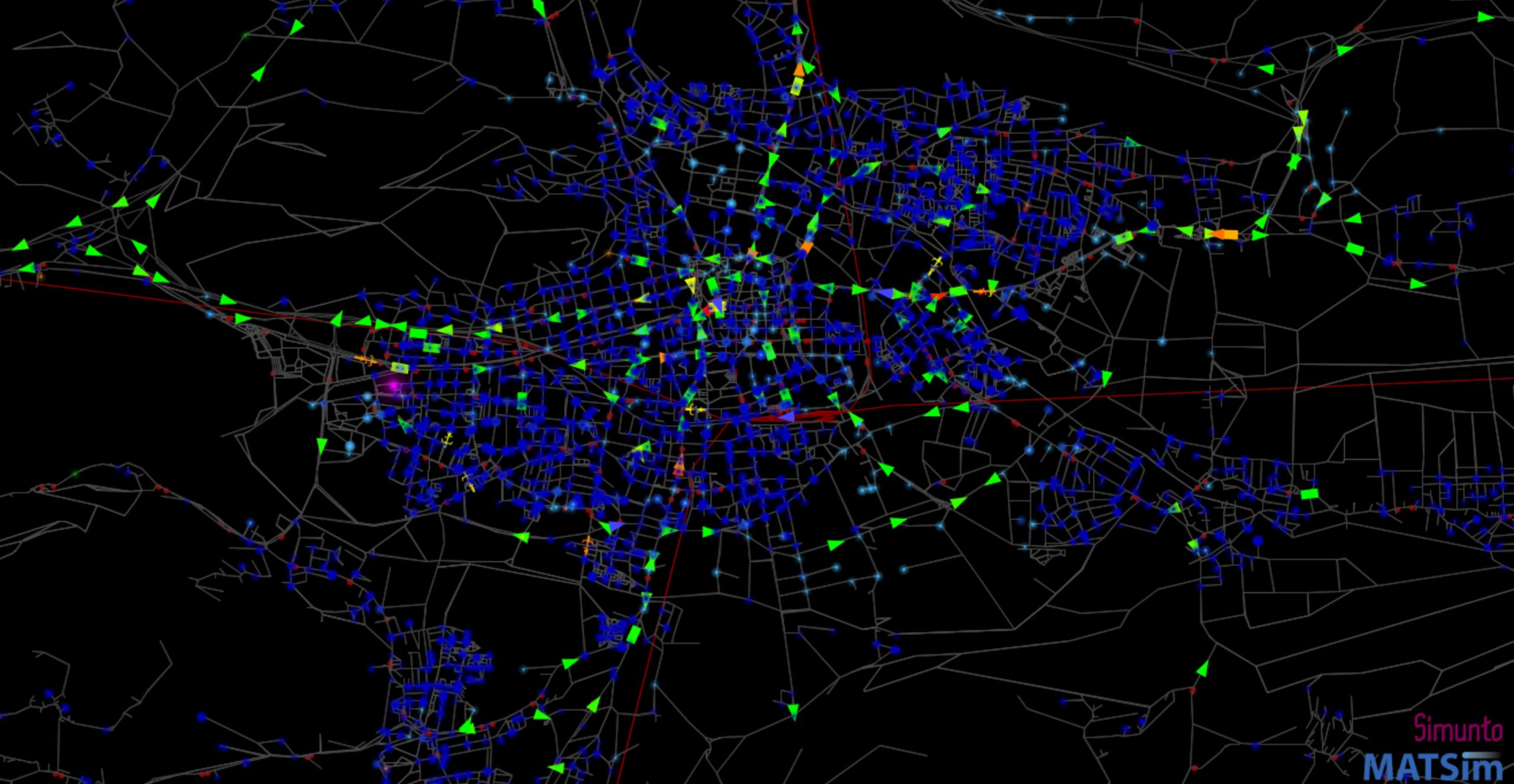
MATSim-Simulation, Credit: JOANNEUM RESEARCH/LIFE
The project
Transport impacts and effects on greenhouse gas emissions (GHG) are determined for a selected scenario for the "Sustainable mobility concept for economic and educational hubs in the central Carinthian region". By illustrating the effectiveness of simulated transport measures at a specific location in more detail we can identify next steps in various mobility measures in general.
Our activities in the project
We develop a method to map traffic effectiveness of new parking organisation scenarios in the area around the Lakeside Park and the University of Klagenfurt.
The three step approach consists of a method for generating input data (i.e. scenarios), simulating these scenarios with our traffic model and developing analysis tools in order to quantify traffic and climate impacts.
Research groups
Downloads
Customers
Lakeside Science &Technology Park GmbH
Project partner
Lakeside Science & Technology Park GmbH
Universität Klagenfurt
Details of the project
The aim of the project is to determine impacts on traffic and greenhouse gas emissions (GHG) for various mobility measures in order to quantify their effectiveness and identify the next steps for their application in real life. We develop a new two-stage (input-output) approach to determine traffic and emission effects for two parking management scenarios for the area around LakeSide Park and the University of Klagenfurt. Scenarios are defined and preselected by considering feasibility, predicted global transport effectiveness and costs of transferability to other educational locations and fed into the LIFE Mobility and Activity Model, an agent-based traffic simulation (traffic flow model) based on MATSim. The traffic model consists of a population with activity chains created on the basis of a detailed survey (Österreich Unterwegs 2013/14). Public transport lines (including new timetables) and network data (road, rail, walking relations) are updated for this project for the reference year 2022. In addition, a new spatial distribution of workplaces/target activities within the selected area as well as a calibration of access routes based on a car park survey (June 2022) is carried out. The chosen modelling approach also maps the interaction with the public space. The results of this study are simulations of the defined scenarios as well as a presentation of traffic and climate-related effects compared to the reference scenario.
Funding
Project participants
Related projects
Miteinander zukunftsrelevant
Die JOANNEUM RESEARCH ist Innovations- und Technologieanbieter im Bereich der angewandten Forschung. Als Forschungsgesellschaft der Länder und Regionen prägen wir mit unseren Forschungskompetenzen die Entwicklung unserer modernen Gesellschaft und Wirtschaft nachhaltig und menschenzentriert. Als multidisziplinäres Team in flexiblen, innovationsfreundlichen Strukturen leben wir höchste gesellschaftliche und wissenschaftliche Ansprüche.