- About us
- Research fields
- DIGITAL – Institut für Digitale Technologien
- MATERIALS – Institut für Sensorik, Photonik und Fertigungstechnologien
- ROBOTICS – Institut für Robotik und Flexible Produktion
- COREMED – Zentrum für Regenerative Medizin und Präzisionsmedizin
- HEALTH – Institut für Biomedizinische Forschung und Technologien
- LIFE – Institut für Klima, Energiesysteme und Gesellschaft
- POLICIES – Institut für Wirtschafts-, Sozial und Innovationsforschung
- Business areas
- Products & services
- Forschungsinfrastruktur
- Beteiligungen
- Career
- Aktuelles
- Publications
- Kontakt zu uns


REAL: Resource-Optimised sub-area management of agricultural land
Duration:
02/2023
—
01/2024
Total project duration:
1 year
Digitale Landwirtschaft, Foto: Maschinenring/Linshalm
The project
How can we improve agriculture in an environmentally friendly way?
Resource-optimized management of farmland or sub-areas is not only an environmentally but also economically valuable contribution towards improving domestic food production. The aim of this project is improving the cultivation of arable land using appropriate application cards and thereby preserving natural resources. These application cards are readable by machine. Meaning the corresponding application equipment is able to utilize these cards.
Our activities in the project
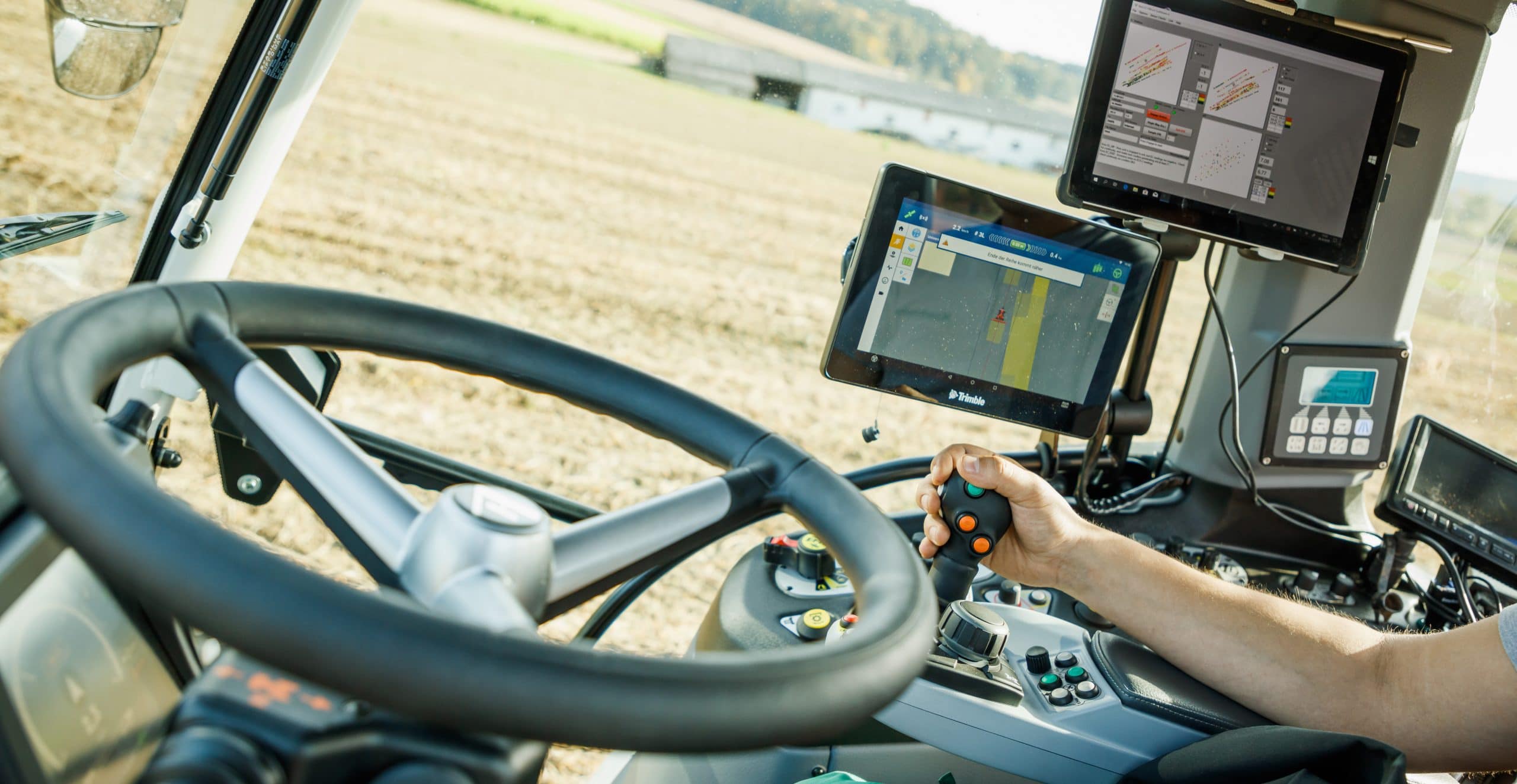
We develop a dedicated evaluation system for the automated identification of homogeneous agricultural areas as well as the provision of application cards for cultivation. It is particularly vital that the area zoning information is provided digitally (machine-readable) for processing by the farming machinery.

Research groups
Downloads
Contracting Authority
FFG
Project partners
aGRAR-ZT
Details of the project
For a resource-optimized management of agricultural land by farmers or agricultural companies, the aim of this project is to identify essential land characteristics influencing the development of various agricultural species. The aim is to identify clusters (zones) within a field, whereby the properties within each cluster are homogeneous and substantially distinguishable from the characteristics of other clusters. For cluster identification, high quality data needs to be processed and scientifically analyzed.
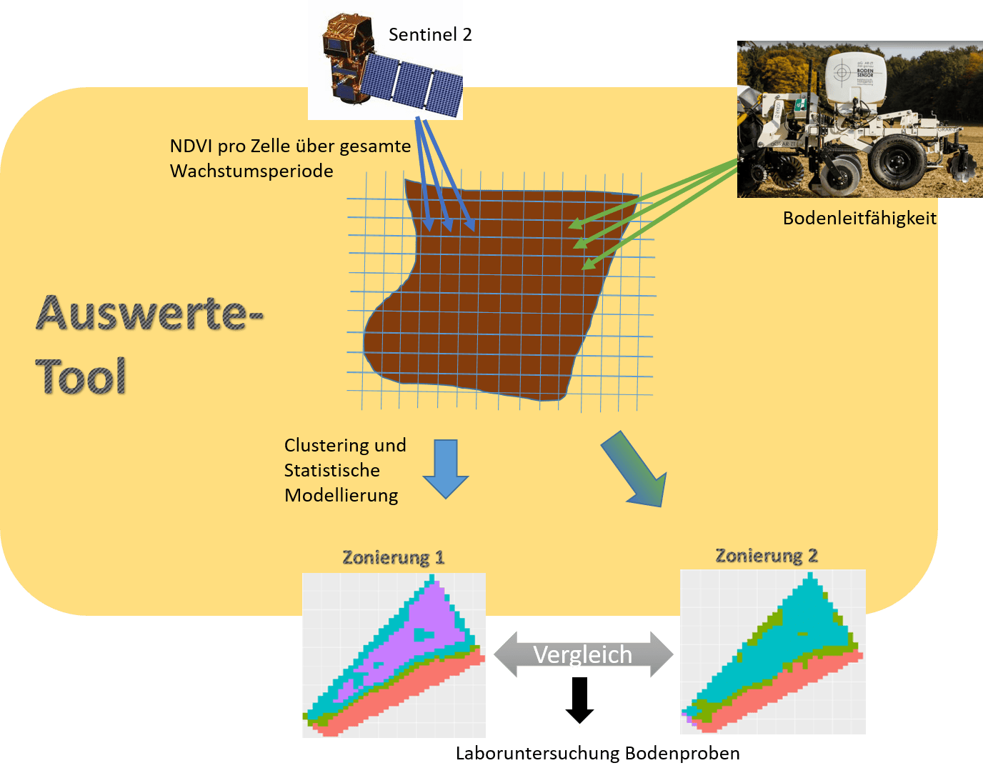
One way to identify the clusters is to use Sentinel-2 high-resolution satellite imagery. High-resolution satellite images are freely available for the entire Austrian agricultural area ( even for Europe as a whole), and the data is continuously recorded throughout the year as well as being publicly available covering several years in the past. The advantage of using plant indices is that they indirectly reflect the nutrient supply and water supply within the field. If the historical data is also included in the analysis, clusters can be identified that differ in terms of their plant development over several years. The clusters are identified using a suitable, spatial-temporal, statistical analysis method (cluster analysis), whereby the number of clusters depends on the respective field size. The identified clusters represent the differing field properties.
Soil samples from each cluster are also analyzed in the laboratory to determine soil types and the nutrient composition of the particular substrate. The grain size composition and the nutrients nitrogen, phosphorus, potassium and magnesium, which are extremely important for plants, are investigated in detail. Furthermore, the soil reactivity via the pH value is also determined in order to establish the required amount of chalk for the corresponding cluster.
A special evaluation tool will be developed as part of the project to ensure that the scientific and statistical analysis of the data and the identification of the individual clusters can be performed not only by plant cultivation experts, but also semi-automatically. With this expert tool, the identified clusters can be generated in machine-readable form and enable site-specific management. In this context, it is particularly important that the results of the area zoning are available in electronic form (machine-readable) to enable their processing by the application equipment (implement, fertilizer spreader).
Since soil information (topsoil and subsoil) should also be taken into account for zonation of cropland, soil sensor data is also examined. The hypothesis is that by combining Sentinel-2 data and soil sensor data, the zoning process will be enhanced. The zonation determined with Sentinel-2 data exclusively and zonation in which soil sensor data is additionally used will be compared in this regard. Using the soil sensor data, including soil electrical conductivity, it is possible to indirectly determine the soil properties and subsequently the moisture concentration in the ground and thus identify the various soil characteristics. The figure shows the procedure for data collection and the associated analysis.
Funding organisation
Project participants
Similar Projects
Miteinander zukunftsrelevant
Die JOANNEUM RESEARCH ist Innovations- und Technologieanbieter im Bereich der angewandten Forschung. Als Forschungsgesellschaft der Länder und Regionen prägen wir mit unseren Forschungskompetenzen die Entwicklung unserer modernen Gesellschaft und Wirtschaft nachhaltig und menschenzentriert. Als multidisziplinäres Team in flexiblen, innovationsfreundlichen Strukturen leben wir höchste gesellschaftliche und wissenschaftliche Ansprüche.