- About us
- Research fields
- DIGITAL – Institut für Digitale Technologien
- MATERIALS – Institut für Sensorik, Photonik und Fertigungstechnologien
- ROBOTICS – Institut für Robotik und Flexible Produktion
- COREMED – Zentrum für Regenerative Medizin und Präzisionsmedizin
- HEALTH – Institut für Biomedizinische Forschung und Technologien
- LIFE – Institut für Klima, Energiesysteme und Gesellschaft
- POLICIES – Institut für Wirtschafts-, Sozial und Innovationsforschung
- Business areas
- Products & services
- Research infrastructure
- Beteiligungen
- Career
- Aktuelles
- Publications
- Kontakt zu uns


BEAT IT!
RUNNING TIME:
07/2020
—
06/2022
Total project duration:
2 Years
The project
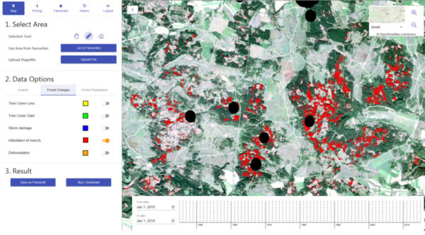
Satellite-based earth observation enables the introduction of an area-based approach to bark beetle monitoring and allows the spread to be tracked over time.
Our activities in the project
Our DIGITAL team developed and tested new methods of analysis for the comprehensive early detection of bark beetle infestations using satellite images from the Sentinel missions. To this end, the recognition and classification of the various causes of damage in forest areas had to be improved in order to be able to quickly recognise new bark beetle infestations. From this, a risk model for the pest infestation could be created with the help of artificial intelligence in order to plan and apply pest control at an early stage.

Research groups
Downloads
Customers
Project partners
Cloudflight GmbH
Umweltdata GmbH
Forstbetrieb Seilern
Project details
Due to climate change, forests in Central Europe are increasingly suffering from storms and droughts, which weakens their resistance to insect infestation. Record numbers of timber damaged by bark beetles have therefore been reported in recent years. The consequences are economic losses for the Austrian and European forestry industry totalling several hundred million euros, but also an impairment of the social and ecological functions of our forests. Current bark beetle monitoring services are mostly based on terrestrial methods, e.g. the determination of beetle populations using pheromone traps. Their limitation is that they can only provide information on specific points and not on the current infestation. It is therefore not possible to quickly recognise new beetle infestations and record their spatial distribution.
In the BEAT IT! project, new analysis methods for the early detection of bark beetle infestations are being developed and tested on the basis of satellite images from the Sentinel missions. Our aim was to quickly detect the spatial infestation and thus optimally support the planning of targeted countermeasures.
The methodological developments are focussed on three subject areas:
- Improved classification and separation of causes of damage in the forest
- Rapid detection of new bark beetle infestations (near real-time component)
- Risk modelling of bark beetle infestations using artificial intelligence (AI) methods and current satellite images
As part of the project, new methods for analysing time series and classifying satellite images are being developed and tested. The methods will be validated in recently infested areas, including those of Österreichische Bundesforste AG and the Seilern-Aspang forestry operation.
After completing the methodological developments, the consortium set up a prototype of a satellite-based bark beetle monitoring service. Forest enterprises and forest administrations are testing this prototype via an interactive web portal. Our aim was to enable forestry companies to plan and apply important bark beetle control measures in risk areas as early as possible and in a targeted manner. The involvement of forestry companies and forestry offices guarantees that all project developments are orientated towards the actual requirements of users and the market.
Funding organisation
Projektbeteiligte
Related projects
SHAPING THE FUTURE, TOGETHER
JOANNEUM RESEARCH provides innovation and technology services in the field of applied research. As a research company working on behalf of various federal provinces and regions in Austria, our expertise shapes the development of our modern society and economy – sustainably, and always with a focus on people. As a multidisciplinary team working in a flexible set-up that fosters innovation, we always live up to the highest social and scientific standards.