DeepDigitalForest
Optimization of a Multi-Phase Inventory- and Assessment System as a Step towards the Digital Forest
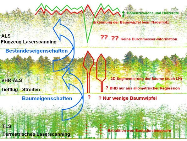
Within DeepDigitalForest, the workflow concept of a consistent, cross-company and cost-efficient forest inventory assessment is extended to include very high resolution (VHR) ALS data. These data sets allow for a better representation of individual trees and more detailed stand characteristics. These new data sets need to be properly included into the current system of ALS and terrestrial data. The key-benefit of this 3-phase forest inventory design is the possible integration into existing National Forest Inventory (NFI) designs with regular grids of permanent sample plots. Existing sample grids designed for monitoring protection areas can be enhanced in the same way. In addition, within the scope of this project new innovative methods of terrestrial laserscanning (patent by Umweltdata GmbH) and AI-based object- and feature extraction from LIDAR point clouds will be implemented, tested and evaluated. Overall goal is to promote the application of these methods in large-scale regional and national forest inventory projects and to set a high standard on international level. This new focus on NFI and large area forest monitoring significantly expands the scope of possible customers for the whole consortium.
The first VHR ALS data sets are now available. Have a look: ALS data almost as detailed as TLS data!